
Seeing a familiar landscape from the air can in a way transform it, revealing the geography of the place in full and sometimes, depending on the place, deepening one’s sense of the divine.
I grew up about 30 miles from the terminus of the Knik Glacier in southcentral Alaska, but had never seen it from the air until this summer. An old family friend offered to take me up for an aerial tour in his 1953 Cessna 180, and we took off from a lake in the Mat-Su Valley not far from where I was raised.
We approached from the southeast, heading along the Chugach Mountains, which rose up on our left. We spotted black bear, moose, and Dall sheep along the southern face of the mountainsides, and in one case were close enough to see the sheen on the coat of a young black bear. At the base of the mountains, four-wheeler tracks used mostly by hunters crisscrossed the woods and riparian plains leading to the river.
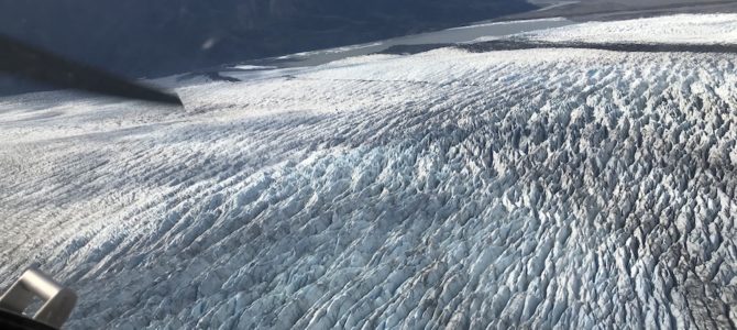
You cannot quite grasp the expanse of a glacier until you see it from the air. The ice field of the glacier itself is about 25 miles long and five miles wide, and feeds the Knik River which terminates in the Cook Inlet, near Anchorage. I’ve spent plenty of time on this river, fishing and camping (sometimes even hunting beer bottles with a shotgun). And I’ve seen the glacier plenty of times while floating on the river.
https://twitter.com/johnddavidson/status/1306747990481285125?s=20
But I’d never seen it like this. It looked alive, like something ancient wending its way down from the mountains. In a way, glaciers are alive. They move, and in moving they shape the earth, destroying and creating as they come and go. The entire Mat-Su Valley, a wide and fertile basin just north of Anchorage, was carved out thousands of years ago by the retreat of the Knik, Matanuska, and Susitna glaciers, whose rivers now flow from three different mountain ranges that ring the valley.
The natural forces at work in these places are awesome and at times terrible. We flew south past the glacier to Lake George, which used to be a “jökulhlaup,” an Icelandic term for a self-dumping glacial lake. Every spring, the breaking up of the glacial ice dam around Lake George would release a torrent of water and debris into the Knik River, cutting off communication and sometimes destroying settlements. This phenomenon ceased after 1967, partly because of changes to land elevation in the area around the lake caused by the Good Friday earthquake of 1964, the most powerful earthquake ever recorded in North America.
— John Daniel Davidson (@johnddavidson) September 18, 2020
Turning back toward the valley, the scene changed abruptly from the primordial ice of the glacier to the deep green forests and fields of the valley, dappled with lakes and rivers and streams, all teeming with life—life made possible by the waters flowing out of the ice and mountains roundabout us.
You can see and touch these things discreetly on the ground, one by one, the rivers and lakes and forests and mountains. But from the cockpit of a small aircraft they spread out before you in a splendorous panorama, and it’s possible to grasp the unity of the whole, if only for a fleeting moment.
One last note about the Knik Glacier: in 1991, it was the setting for a scene in “Star Trek VI: The Undiscovered Country,” when Kirk and McCoy are rescued from the Klingon prison planet Rura Penthe. Rest assured, as kids my brothers and I were well aware of this when Star Trek VI came out, and we thought it was awesome. Because it is.