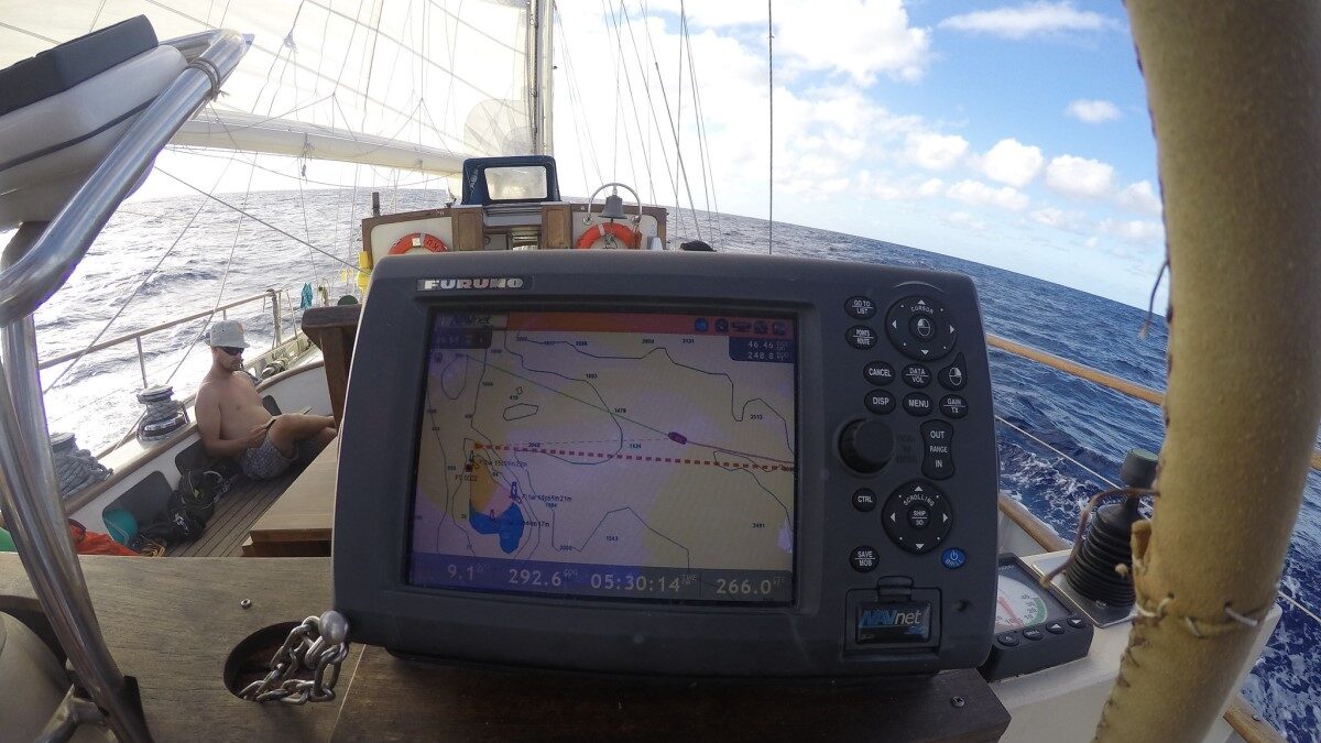

With the letters GPS, we instantly recognize an innovation that has revolutionized our lives. The concept was born half a century ago in a sweltering room at the Pentagon over Labor Day weekend in 1973.
That’s the genesis of the concept for a constellation of platforms orbiting the Earth, transmitting radio signals to determine location. Many years of calculation, experiment, and miniaturization led to the Navigation Signal Timing and Ranging (NAVSTAR) satellites that became known as the Global Positioning System (GPS).
The dedication and intellect of the engineers, scientists, and technicians involved led the way to worldwide freedom from getting lost — and governments’ ability to always know where you are if you’re carrying a phone.
Ancient and Medieval Navigation Techniques
Ancient and medieval navigation employed a variety of techniques, depending on opportunity: piloting, celestial mapping, and dead reckoning as a last resort. A pilot could recognize geographical markers, such as rivers, mountains, coasts, and light-houses, along with smaller landmarks. However, these references were unavailable in open water.
Assuming an initial location, dead reckoning involved calculating one’s current position based on direction heading, estimated speed, and elapsed time. The sun, moon, and stars serve as regular bright objects at sea for such navigation. Unfortunately, cloud cover obscures these, as occurred in storms when dead reckoning was at its most perilous.
For the northern hemisphere, the pole star offers an arrow towards the Arctic. Today, Polaris in Ursa Minor holds this position. Due to the Earth’s precession, this honor belonged to Thuban in Draco during the construction of the Giza pyramids. In 12 millennia, the north pole will point towards the star Vega.
From the north, Earth’s axis points to a position in the sky that turns counter-clockwise in a circle across 26 millennia, as illustrated in the star chart below.
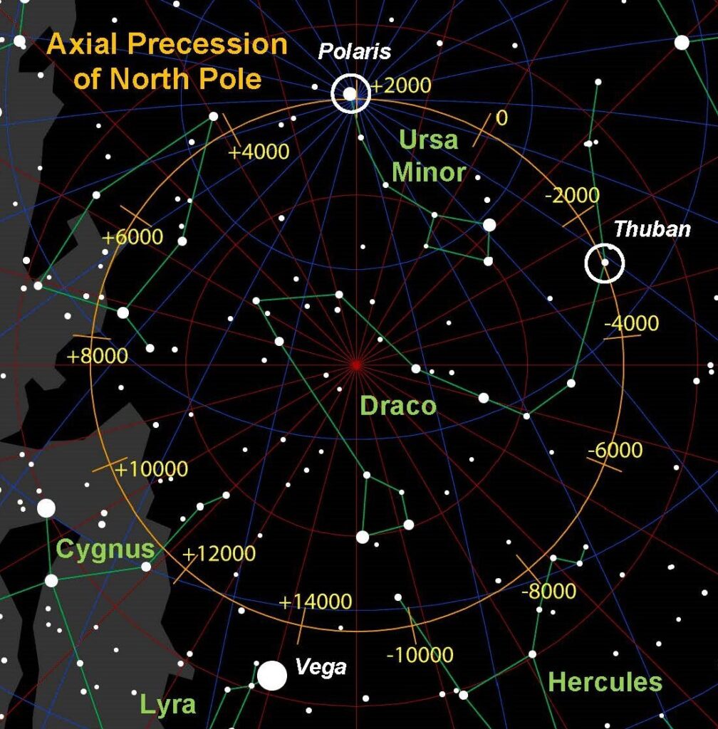
Due to the moon’s gravitational influence, the Earth’s rotational axis wobbles as a toy spinning top. This compounds all the other navigational challenges.
Navigation Miscalculations Can Kill
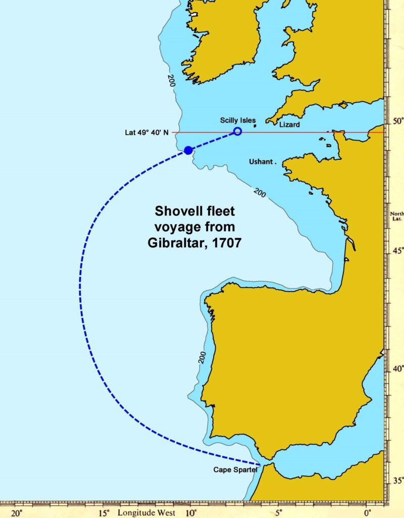
Using stars to navigate sometimes led to tragic consequences. In late autumn 1707, the Royal Navy sailed 21 gunships from Gibraltar to Portsmouth. While voyaging south of Ireland, the fleet encountered inclement weather on approaching England. Navigation error caused four of the ships to founder at the Isles of Scilly, while two others suffered damage.
This naval disaster cost almost 2,000 sailors their lives and prompted Parliament to commission a reward for determining longitude more accurately.
Medieval nautical advancements included charts to plot courses, cross-staffs, and astrolabes for converting to latitude, sandglasses to mark time, and magnetic compasses to align direction, especially in cloud cover. The mid-19th century introduced sextants. Seaworthy chronometers became affordable in the 19th century.
Gyroscopic inertial guidance and radio reception were adopted in the early 20th century. Both principles improved with electronic miniaturization, then when supplemented with echolocation like sonar and radar.
Employing such tools in any era requires training and skill. Yet even these modern tools yield errors. That includes in 1983, when passenger flight KAL-007 strayed into Soviet airspace, where it was shot down with the loss of all lives aboard.
The Beginnings of Satellite Positioning
So how did that all change? A few days after the Soviet Union launched Sputnik a few hundred miles above the Earth’s surface, scientists at the Johns Hopkins Applied Physics Laboratory realized the satellite could be tracked from the ground merely by the radio signals its transmitters emitted by exploiting the Doppler shift as it passed.
In August 1966, the U.S. Air Force submitted proposal 621B to engage these principles in reverse: using the satellite to locate a ground position, such as for search-and-rescue operations. Although useful for military use, that was not economically scalable. It also required an enormous quantity of satellites for global coverage from low-Earth orbit.
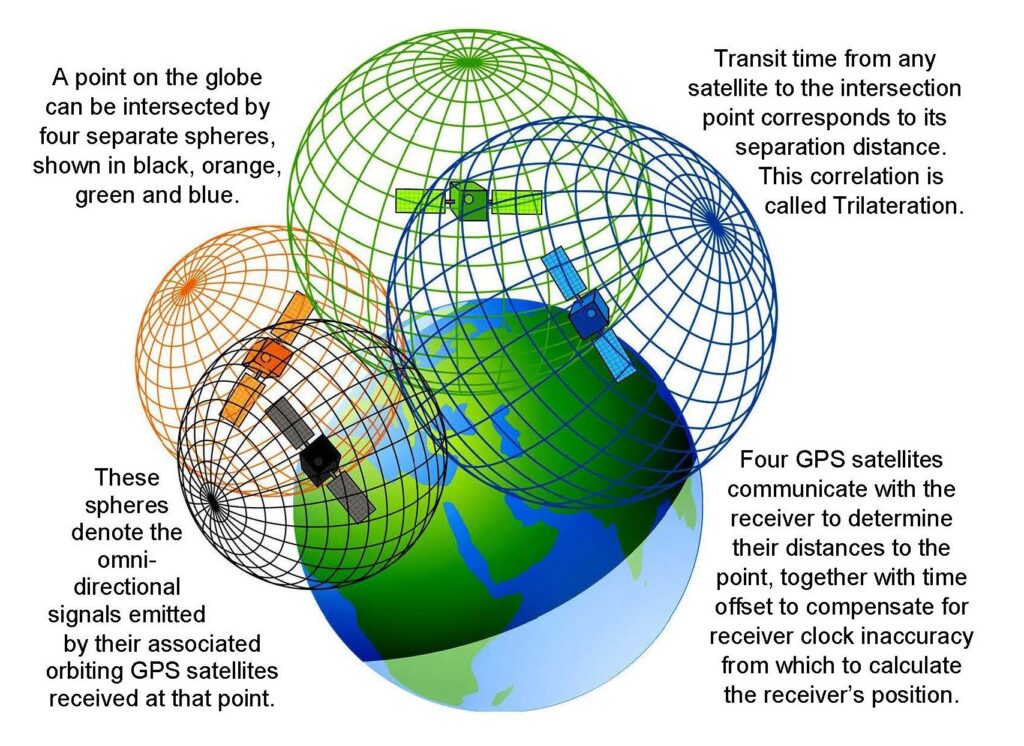
Then over Labor Day weekend in 1973, a group of U.S. Air Force officers led by Col. Bradford Parkinson met in empty Pentagon rooms to bring this idea to fruition. Ground receivers had to be passive, with no feedback to the transmitters in orbit. The system had to operate worldwide. Intersection from four separate signal emitters within the line-of-sight would correspond to a single receiver location.
Measuring the time elapsed can calculate the distance between the satellite and the receiver. Depending on these time delays, the intersection of the spheres corresponds to the receiver’s location, allowing trilateration plus time offset to compensate for the receiver’s temporal inaccuracy. The convergence in this example points to a location in northern Europe.
Configuring GPS
The Atlas booster then available constrained the payload mass for reaching medium orbit. The teams chose a constellation of at least 24 platforms with 12-hour orbital passes at 12,500-mile altitude to satisfy payload requirements, mapped into six orbital planes with four or five satellites per plane.
To distinguish multiple satellites operating on the same frequency, James Spilker at the company Aerospace created code division multiple access, or CDMA. This technique assigns a particular identifier to each transmitter.
Richard Schwartz and Hugo Fruehauf at Rockwell miniaturized and radiation-hardened rubidium vapor oscillators to serve as the NAVSTAR atomic clocks. These achievements from Air Force, Rockwell, and Aerospace teams are summarized in the Lonely Halls documentary.
Fixing What Went Wrong with the Concept
Sources of errors for this plan abounded. Among these included space-time dilation, revealed by Albert Einstein in 1905 and 1915. Due to special relativity, the NAVSTAR satellite’s orbital speed of 2.4 miles per second decelerates the clocks by seven microseconds per day.
By contrast, general relativity speeds up those same clocks by 45 microseconds per day due to the GPS satellite’s greater distance from the Earth’s core. That reduces that gravitational influence compared to the surface.
Together, failure to compensate for these effects induces an error of more than six miles per day. So before launch, the satellite clocks are slowed down by 0.000000045 percent to synchronize with ground stations.
Additional sources of error include free electrons in the ionosophere, Sagnac distortion, and Earth’s axis perturbations called the Chandler wobble. GPS compensates for these by incorporating two separate transmit frequencies, calibrated against each other, as well as atmospheric modeling and coordinate transformation between transmitter and receiver.
GPS Finally Launches in the 1970s
Led by Roger Easton, Naval Research Laboratory developed a pair of proof-of-concept satellites to test time-based navigation. These were launched in 1974 and 1977.
Starting in February 1978 and continuing until October 1985, the Air Force launched 10 prototype Block-I NAVSTAR satellites aboard Atlas F rockets for testing. From February 1989 through November 1997, it launched nine Block-II and 19 Block-IIA by Rockwell aboard Delta-II rockets (after the exclusion of the Space Shuttle). This formed the initial GPS constellation.
Today, 31 GPS satellites remain operational, not counting four reserve or spare platforms. Various improvements have been incorporated.
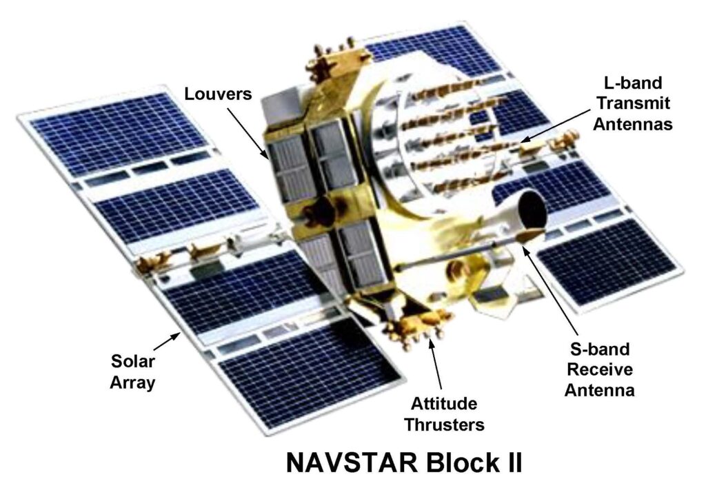
Throughout their development, GPS satellites have shared common features. Shown below is the Block-II configuration, weighing about one ton (about double the prototype Block-I). Louvers on the side dissipate excess heat via thermal radiation to maintain consistent internal temperature. Attitude thrusters adjust satellite orientation. Photovoltaic solar arrays convert sunlight into electrical power.
From Concept to Millions of Uses Every Day
Despite resistance from top military brass, many service personnel during the first Gulf War in 1991 requested their families send them civilian GPS receivers. Then the Defense Department began equipping personnel and road vehicles with ruggedized receivers.
Initially, the GPS signal was degraded for non-decrypted receivers, limiting its public acceptance. In May 2000, the government discontinued this policy, opening commercial navigation opportunities. Now, everyone can find his location within seven feet anywhere on the globe.
In February 2019, four of the primary contributors to GPS were honored with the Queen Elizabeth Prize for Engineering. These men’s achievement serves all mankind, yet is so often taken for granted.

Our society has been blessed with rare and precious genius that has combined across centuries to yield the civilizational achievements we enjoy today. Orbital mechanics originated from careful geometric analysis by Johannes Kepler in the 17th century. Two centuries later, electromagnetism was empirically measured by Michael Faraday and mathematically characterized by James Clerk Maxwell.
Atomic oscillation arose from the quantized radiation law Max Planck discovered, while Albert Einstein discovered relativistic effects, both in the early 20th century. These were the giants on whose shoulders later scientists and engineers stood to build their guideposts in the heavens.
While only a tiny fraction of the electorate understands the enormity of government waste, fraud, and abuse, now and then we learn of some extraordinary achievements underwritten with your tax dollars. GPS is one of them.
When you travel to visit relatives at Thanksgiving and Christmas, remember the fleet of beacons helping get you there, and the outstanding technical pioneers who made that feat possible.