Today when we open an app to try to figure out where we are, or where on earth our driver is, we’re usually not thinking about the time and care that went into creating the map before us on the screen. Human beings have been charting the sea, land, and skies for millennia, but apart from those who work in fields like geography, astronomy, and cartography, most of us don’t give a passing thought as to how and why our maps look the way that they do.
Yet some very famous artists used their artistic skills to create maps, and in two interesting examples from the 16th century, we’ll see that the maps created by these artists had important effects, not just on art history, but on a host of other areas, from military strategy to science, politics to private life.
Western artists have often included maps in their paintings, particularly during the age of exploration and European imperial colonization. Johannes Vermeer’s famous “The Geographer” (1669), now in Frankfurt’s Städelsches Kunstinstitut, is a well-known example. Not for the first time in one of his paintings, Vermeer shows a map hanging on the wall in the home of a Dutch cartographer, as well as a globe sitting on top of a cupboard.

Similarly, in Edward Savage’s iconic group portrait “The Washington Family” (completed 1796) at the National Gallery of Art, we see a map spread out on the table between George and Martha, while one of their grandchildren rests his hand on a globe. In these examples, maps were depicted as elements of an overall composition, rather than as fully legible, practical objects in their own right.

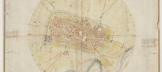
During the Renaissance, however, two of the most important artists in history turned their hands to mapmaking itself. It will probably not surprise you to learn that one was Leonardo Da Vinci (1452-1519), since his creative genius led him to experiment with just about everything. A particularly important example of Leonardo’s innovative skill as a mapmaker is his “Plan of Imola” (1502), which today is in the Royal Collection at Windsor Castle.
The Artist as Spy Satellite
Leonardo’s map was one of a series created for the infamous Cesare Borgia (1475-1507), who in 1499 captured the fortified city of Imola in northern Italy, and turned it into one of his military strongholds. Because he was unfamiliar with the strategically significant town, Borgia needed a detailed map to help him understand how to defend it.

For this, Borgia turned to his military architect and engineer, da Vinci, whom he had hired to study the Romagna region as part of his plans for taking possession of it.
During his five months of wanderings about the countryside, Leonardo wasn’t particularly impressed by those Borgia was seeking to subdue. In his notebooks for this period, he wrote: “In Romagna, the kingdom of all stupidity, vehicles with four wheels are used, of which the two in front are small and two higher ones are placed behind: an arrangement which is very unfavorable to motion, because more weight is laid on the front wheels than on those behind.” Whatever his thoughts about the people of Romagna, however, the artist came to understand and to represent their territory in a way unlike anyone else before him.
As you can see, in his “Plan of Imola” Leonardo combines pen and ink drawing with color washes to indicate such features as the city’s walls, buildings, and streets, as well as the roads, river, and natural features that lie outside the town. Originally, the map was more brightly colored, but over time the green pigments of the fields and the red pigments of the roofs have faded to a brownish yellow, while the light blue of both the moat surrounding the city walls and the river laying to the south of the city has become a somewhat silvery color.

Given the size of the drawing, at about 2 feet by 1.5 feet, this was clearly intended to be a practical object for a military man and his advisors to carry about, not simply a decorative art object to be put on display.
What is particularly innovative about this image, and may not reveal itself upon a mere perusal, is the way in which Leonardo chose to think about, study, then represent his subject. Unlike most maps from this period, which often showed cities and towns from a point of elevation such as a tower or hilltop, and almost never to scale, Leonardo created what historians consider to be an extremely accurate view of Imola, as it would have appeared from a high vantage point directly above the city sometime in the summer of 1502. In essence, he anticipated an app like Google Earth by more than 500 years.
To create this map, Leonardo took pains to measure as much of the town as possible, such as by pacing off the width of streets and distances between structures. This led to a far greater degree of accuracy in the representation of Imola’s layout, so a military figure like Borgia would know exactly where to station his men, if defending, or where the weakest points in the defenses were located, if attacking. To some extent, then, this map could be said to be an ancestor of every image captured by military drones and spy satellites today.
A New Heaven and Earth
Another major Renaissance artist, Albrecht Dürer (1471-1528), made his contribution to the history of mapmaking a little more than a decade after Leonardo’s. Dürer was the most important painter of the German Renaissance, but arguably his greatest artistic achievements lay in the innovations he brought to creating highly detailed woodcuts and engravings.
Thanks to the new-fangled mechanical printing press, which had been invented in Germany in the mid-1400s, Dürer’s prints could be more quickly mass-produced for distribution to a far wider audience than could have seen or obtained one of his original paintings. Prints such as “The Four Horseman of the Apocalypse” (1497/8) and “Melancholia” (1514) were highly prized by collectors, went on to influence centuries of later artists, and appeared as posters in the dorm rooms of many morose college students.

Like Leonardo before him, Dürer was approached to create a series of maps. Also like Leonardo, he brought an innovative outlook to the project. The methodology underlying the data contained in these maps comes from the work of scientists rather than, as in the case of Leonardo’s maps for Borgia, detailed measurements the artist took himself. Nevertheless, Dürer managed to translate that data into maps that provided practical, yet for the time unique ways of looking at the world.
In his “Celestial Maps of the Northern and Southern Skies” (1515), Dürer created the very first printed star charts in Europe. He worked with the Austrian cartographer and imperial astrologer Johannes Stabius (1450-1522) to combine all of the known knowledge of the time regarding the constellations, culled from Greek, Roman, Arabic, and other sources.


The artist translated this information into a highly effective, and hugely popular, pair of detailed woodcuts, combining scientific observation with imagery from mythology in a way that remained the standard in Western celestial maps for centuries.
Each of the maps is roughly 2 feet by 1.5 feet, just like Leonardo’s “Plan of Imola,” meaning these prints were intended to be used, not simply displayed on a wall or in an album. At a time when people still governed their travels—and indeed, sometimes their entire lives—by reading the stars, these maps of the constellations were invaluable to those who needed to be able to plot out where, exactly, they were.
We can also see, in his map of the skies over the Southern Hemisphere, how little Europeans knew of the night sky in that part of the world in the early 16th century. However, Dürer’s greatest artistic and conceptual innovation lay in helping to create a truly forward-looking map of the globe—or, at least, of as much of the globe as was known to him at the time he created it.
After the Stars, to the Earth
In the same year that he printed his celestial charts, and in collaboration with Stabius and others, Dürer created his “Map of the World” (1515). Apart from some bad but interesting understanding of the geography of places such as India, the significance of this map lies not so much in its design or its decoration, but its orientation.
What Dürer created, in fact, is the very first known illustration of the planet as a spherical map, shown in perspective, and incorporating all of the geography known to Europeans at the time. Today, we might see this map on a wall or reproduced in a book, and think nothing of it other than that it represents an early understanding of the world.

But to someone living in the 16th century, this was a radical reimagining of how to represent and understand the planet. Despite it being such a forward-looking, innovative concept, few today know or appreciate that the idea for rendering the world like this comes from one of the most important of all Renaissance artists.
It’s fascinating to think about what these maps by Leonardo and Dürer have meant to the history of mankind. Leonardo’s renderings of Romagna, for example, helped fuel the Borgia’s insatiable lust for power, keeping parts of Italy at war for years even in the midst of the flowering of the Renaissance. Dürer’s world map informed the geo-political decisions of emperors, kings, and princes, while his maps of the heavens helped sailors across Europe to set out for distant ports or unknown parts of the world, using his highly accurate charts of the night skies for navigation.
Perhaps most importantly, as we have seen, these two artists’ innovative and influential ways of looking at the concept of mapmaking, from its function to its appearance, continue to echo to us today.